 Build career skills through hands-on training with a Micro-Certificate in Geographic Information Systems. Designed to fit with any degree and any major, the Micro-certificate can be completed
in as few as three semesters. GIS-specialists work in a range of fields, from transportation
and urban planning to data science.
Build career skills through hands-on training with a Micro-Certificate in Geographic Information Systems. Designed to fit with any degree and any major, the Micro-certificate can be completed
in as few as three semesters. GIS-specialists work in a range of fields, from transportation
and urban planning to data science.
Have you ever wondered how companies develop timely and efficient delivery routes? How about how a major retailer decides where to open their next store? Or how emergency responders target their resources to those who need them most? The answer is GIS.
Geographic Information Systems are a suite of technologies that are used to map data. By integrating data on where things are with descriptive information, GIS is the foundation for mapping and analysis used across almost every industry and in many scientific fields. These technologies allow users to identify patterns, analyze relationships, and understand greographic contexts.
GIS is used in nearly every industry and scientific field. Whatever your career goals, a micro-certificate in GIS will help you get there.
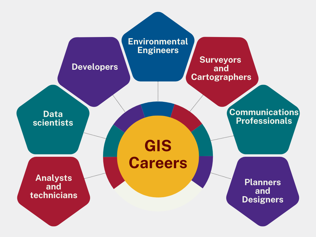
Learn more about careers available to those with GIS training:
GIS Technicians and Analysts use specialized GIS software, cartography skills, and
data analysis to manage geospatial data, and provide data-driven insights that guide
decision making.
GIS Technicians and Analysts work for a varity of businesses and organizations, including
government agencies, environmental consultancies, urban planning firms, real estate
developers, utility companies, and businesses.
Geospatial Data Scientists collect, manage, and analyze location-based data. They are leaders in designing project pipelines, creating approaches that can solve real-world problems and predict future conditions
Geospatial Data Scientists work for government agencies, tech companies, consulting firms, and research institutions.
GIS Developers are software developers with expertise in geospatial technologies and approaches. They specialize in creating, maintaining, and managing GIS tools and software applications.
GIS Developers work for government agencies, environmental consulting firms, and private sector companies.
Environmental engineers apply engineering principles to protect human health and the environment by addressing issues like pollution, waste management, and resource conservation.
Environmental Engineers work in a variety of sectors, including government, industry, and consulting.
Surveyors and Cartographers create precise maps of the Earth's surface to provide crucial information for construction and infrastructure development. They use a variety of geospatial technologies, including GIS software, drones, and photogrammetry software.
Surveyors and Cartographers work in a varity of industries, including engineering firms, government agencies, construction firms, and private companies
Communications Professionals who work in fields like urban planning, public health, crime analysis, and environmental science often leverage GIS for effective data visualization, analysis, and communication.
Communications Professionals who use GIS work in diverse fields like government agencies, environmental organizations, utilities, retailers, insurance agencies, business intelligence, and public health.
Planners and designers utilize GIS to analyze data, visualize maps, and make informed decisions about urban spaces, site selection, and environmental impacts.
Urban Planners and Designers are hired by government agencies, environmental consulting firms, planning firms, and real estate developers.
The Micro-Certificate in GIS curriculum consists of 8-10 credit hours of coursework. Each course provides students with hands-on training working with Geographic Information Systems, Remote Sensing, and Geospatial Technologies. Students learn to use GIS to address real-world problems and scenarios across a range of fields.
Option A - Internship or Research (8-10 cr) |
Option B - Coursework (10 cr)
|
Required Courses
GIS ElectiveChoose one of the following:
Research or InternshipComplete at least 1-cr internship or independent research
|
Required Courses
GIS ElectiveChoose two of the following:
|
Introduction to Geographic Information Systems (GIS), a powerful technology that combines layers of data in a computerized environment. Students learn to create and analyze maps, and solve problems with spatial analysis.
Course will give an introduction to the three primary geospatial technologies: Global Positioning Systems (GPS), Geographic Information Systems (GIS), and Remote Sensing.
Theory and techniques of remote sensing and its application to environmental analysis.
Course provides practical experience using Geographic Information Systems (GIS) to support real-world decision-making and scientific research. Focuses on concepts and approaches to vector and raster modeling within GIS. Prerequisite: GEOG 305 or GEOG 308 or permission of instructor.
Students participate in scholarly research with a faculty member.
An opportunity for students to earn academic credit for experience gained through apprenticeship work under the supervision of a trained professional.
Professionalization and career preparation for Geographic Information Systems and Geospatial Technology careers. Students prepare a professional GIS portfolio showcasing their geospatial work. Additional opportunities for networking and career preparation provided. Intended for students completing the Micro-Certificate in GIS, but open to students who have taken at least one GIS course. Prerequisite: GEOG 305 or GEOG 308 or GEOG 320 or GEOG 330 with a minimum grade of C-; or permission of instructor.
 Dr. Lauren Kohut
Assistant Professor of Environmental Studies and Anthropology